Hooker Valley Track NZ: Aoraki/Mount Cook Hike Guide
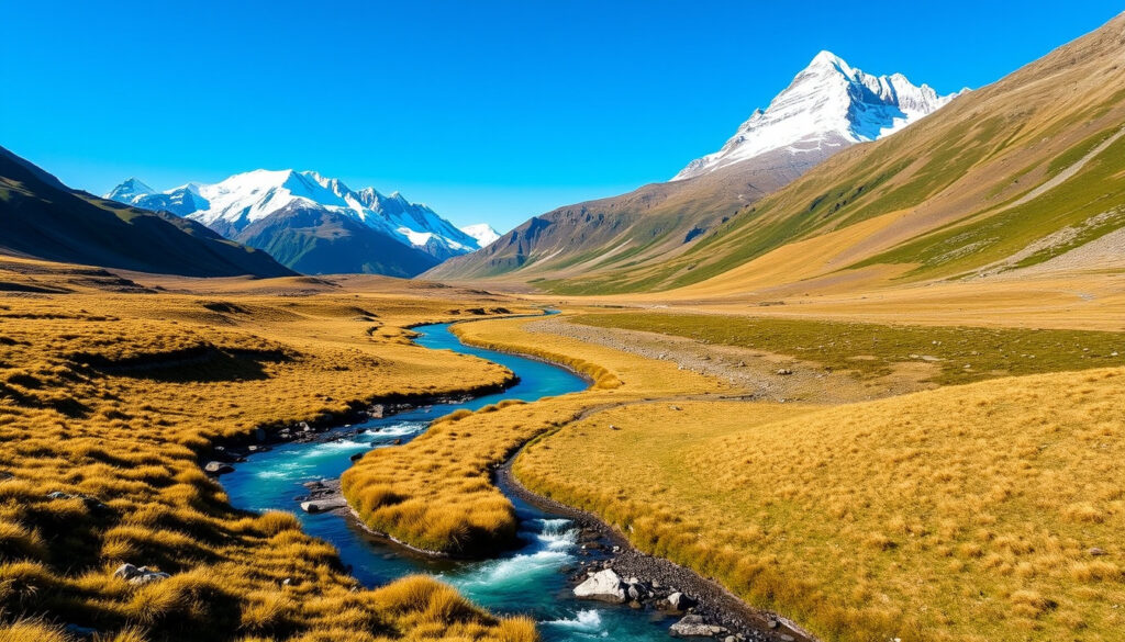
Few hikes in New Zealand deliver such a rewarding alpine panorama for such a modest effort. The Hooker Valley Track, an 11-kilometer return walk in Aoraki/Mount Cook National Park, draws visitors year-round with its views of New Zealand’s highest peak and the iceberg-dotted Hooker Lake (Department of Conservation). But as of 2025, the track has faced partial closures due to bridge construction, so knowing the current conditions is essential before you set out.
Distance: 11 km (6.8 mi) round trip ·
Duration: 3–4 hours ·
Elevation gain: 216 m (708 ft) ·
Difficulty: Easy to intermediate ·
Current status: Partially closed due to bridge construction
Quick snapshot
- Distance: 11 km round trip (Department of Conservation)
- Duration: 3–4 hours (Department of Conservation)
- Difficulty: Easy to intermediate (Department of Conservation)
- Elevation gain: 216 m (Department of Conservation)
- November to April (late spring to early autumn) for stable weather (100% Pure New Zealand)
- Check weather forecast before starting (Department of Conservation)
- Be prepared for rain and wind even in summer (Earth Trekkers)
- Views of Aoraki/Mount Cook (Department of Conservation)
- Hooker Lake with icebergs (Earth Trekkers)
- Swing bridges over glacial rivers (Department of Conservation)
- Alpine meadows and moraine landscapes (Britz)
- Partially closed due to bridge construction (Department of Conservation media release)
- Check DOC website for latest updates (Department of Conservation)
- Alternative routes available: Kea Point Track, Tasman Valley Track (100% Pure New Zealand)
A quick-reference table below assembles the official statistics from the Department of Conservation.
| Label | Value | Source |
|---|---|---|
| Distance | 11 km (6.8 mi) round trip | Department of Conservation |
| Duration | 3–4 hours | Department of Conservation |
| Elevation gain | 216 m (708 ft) | Department of Conservation |
| Difficulty | Easy to intermediate | Department of Conservation |
| Start point | White Horse Hill Campground (recommended) or The Hermitage | Department of Conservation |
| End point | Hooker Lake | Department of Conservation |
| Open status | Partially closed – bridge construction ongoing | Department of Conservation media release |
What is the most beautiful hike in New Zealand?
Ask any local or browse a single Instagram feed, and the Hooker Valley Track will appear near the top of any “most beautiful” list. The combination of Aoraki/Mount Cook’s sheer face, the turquoise Hooker Lake, and the alpine meadows framed by glacial moraine makes it a strong contender for the country’s most scenic short walk (Earth Trekkers).
How does Hooker Valley Track compare to other scenic hikes?
Three distinct walks in Aoraki/Mount Cook National Park offer different perspectives on the same landscape. The comparison below shows what each delivers.
The pattern is clear: lengthier does not always mean more rewarding.
| Track | Distance (return) | Difficulty | Key feature |
|---|---|---|---|
| Hooker Valley Track | 11 km | Easy to intermediate | Views of Aoraki/Mount Cook, Hooker Lake, swing bridges |
| Kea Point Track | 3 km | Easy | Viewpoint of Mueller Glacier and Mount Cook |
| Tasman Valley Track | 4.5 km | Easy | Glacier lake with icebergs, shorter walk |
Sources: Department of Conservation (Hooker Valley), Department of Conservation (Kea Point), Department of Conservation (Tasman Valley).
What makes Hooker Valley Track so photogenic?
Three swing bridges, each crossing a braided glacial river, create natural foregrounds for the mountain backdrop. The track ends at Hooker Lake, where small icebergs calved from the Hooker Glacier float in the water (Britz). The entire route is designed to avoid avalanche risk, keeping the path open and safe for most of the year (Department of Conservation).
For photographers, the 11 km return is a low-effort, high-reward investment. The walk is essentially a moving gallery of alpine scenery, with the best light falling in the early morning or late afternoon.
What is the best month to hike in New Zealand?
The broader hiking season in New Zealand runs from late spring through early autumn, but the Hooker Valley Track is open year-round, weather permitting (100% Pure New Zealand). The key is understanding how the seasons affect track conditions.
What is the ideal season for Hooker Valley Track?
November to April offers the most stable weather, with longer daylight hours and milder temperatures (100% Pure New Zealand). During these months, the track is typically snow-free, and the swing bridges are fully operational when not undergoing construction.
How does weather affect the track conditions?
Even in summer, conditions can change rapidly. Rain can make the gravel path slippery, and wind gusts in the valley can be strong. The Department of Conservation advises checking the forecast before setting out and carrying rain gear at all times (Department of Conservation). Winter hiking is possible but requires crampons and experience with ice.
A dry forecast in July doesn’t guarantee a dry trail. The track’s proximity to the Hooker Glacier means microclimates can produce rain or mist even when the car park is sunny. Always carry a waterproof layer.
The implication: even in optimal months, treat the weather as a variable, not a given.
What is the easiest Great Walk in New Zealand?
The Hooker Valley Track is often mistaken for a Great Walk, but it’s not one of the 10 official Great Walks of New Zealand. The easiest Great Walk is generally considered the Abel Tasman Coast Track or the Lake Waikaremoana Track (Department of Conservation Great Walks).
Is Hooker Valley Track a Great Walk?
No. The Department of Conservation classifies it as an “easy to intermediate” walking track, not a multi-day tramp. It lacks the huts and overnight facilities that define a Great Walk (Department of Conservation).
How does Hooker Valley’s difficulty compare to the easiest Great Walk?
The Abel Tasman Coast Track is 60 km over 3–5 days, with some tidal crossings. The Hooker Valley Track is a 3–4 hour day walk with almost no elevation gain (216 m over 11 km). In terms of effort per hour, the Hooker Valley Track is significantly easier than the easiest Great Walk (Britz).
What to beware of in New Zealand?
New Zealand’s backcountry is beautiful but demands respect. For the Hooker Valley Track, the main hazards are weather, river crossings, and sandflies.
What safety precautions should I take on Hooker Valley Track?
- Check the Department of Conservation website for track closures and bridge status (Department of Conservation).
- Carry a rain jacket, warm layer, sun protection, and at least 1.5 litres of water per person (Earth Trekkers).
- Start early to avoid afternoon winds and crowds (Britz).
- Stay on the marked track; the park is designed to avoid avalanche paths, but venturing off can be dangerous (Department of Conservation).
What are common hazards in New Zealand hiking?
- Rapid weather changes: conditions can shift from sun to snow in minutes (Department of Conservation).
- River crossings: swing bridges are generally safe, but after heavy rain the approach paths can be muddy and slippery (Department of Conservation media release).
- Sandflies: present in the valley, especially near water. Bring insect repellent (Where in the World is Nina).
The catch: most hazards are manageable with preparation—sandflies remain the most persistent annoyance.
What is the toughest walking track in New Zealand?
The Hooker Valley Track is not among the toughest. New Zealand’s hardest day walks include the Tongariro Alpine Crossing, the Routeburn Track, and the Kepler Track (Department of Conservation Great Walks).
How does Hooker Valley Track compare in difficulty?
With only 216 m of elevation gain over 11 km, the Hooker Valley Track is a gentle walk compared to the steep climbs and exposed ridges of the Tongariro Alpine Crossing, which has over 700 m of ascent and takes 7–8 hours (Department of Conservation Tongariro).
What are the hardest tracks in New Zealand?
The Routeburn Track (32 km, 2–4 days) and the Kepler Track (60 km, 3–4 days) demand fitness, navigation skills, and overnight gear. The Hooker Valley Track, by contrast, is a family-friendly day walk that requires no special equipment (Department of Conservation Great Walks).
If you want a challenge, the Hooker Valley Track will disappoint. But if you want to immerse yourself in alpine grandeur without the physical toll of a multi-day tramp, it’s the best short walk in the country.
How to plan your Hooker Valley Track hike
Follow these steps to make the most of your visit, especially given the ongoing partial closures.
- Check the current status. Visit the Department of Conservation Hooker Valley page for the latest track conditions and any bridge closures.
- Pick your start point. Park at White Horse Hill Campground (recommended) or take the shuttle from The Hermitage. The walk begins from the car park (Department of Conservation).
- Pack essentials. Bring water, snacks, a rain jacket, sunscreen, sunglasses, and insect repellent. A camera is a must (Earth Trekkers).
- Start early. Aim to begin by 8:00 AM to avoid midday crowds and afternoon winds. The track is popular, and parking fills up quickly (Britz).
- Enjoy the walk. Follow the gravel path across three swing bridges, through alpine meadows, and end at Hooker Lake. Allow 3–4 hours for the return trip (Department of Conservation).
Confirmed facts and what’s unclear
Confirmed facts
- Track length is 11 km round trip (Department of Conservation).
- Elevation gain is 216 m (Department of Conservation).
- Track is partially closed due to bridge construction (Department of Conservation media release).
- Duration is 3–4 hours (Department of Conservation).
- Start point is White Horse Hill Campground or The Hermitage (Department of Conservation).
What’s unclear
- Exact reopening date for the closed sections – the Department of Conservation website provides ongoing updates but no firm timeline (Department of Conservation).
- Whether all swing bridges are operational during construction – currently the second bridge is closed, and the walk to the first swing bridge remains open (Department of Conservation media release).
What hikers are saying
“The Hooker Valley Track is a 3-hour return easy to intermediate walking track in Aoraki/Mount Cook National Park. It is designed to avoid avalanche risk and visitors should keep to the tracks.”
— Department of Conservation (official park page)
“Great views of Mount Cook, moderate hike, takes about 2.5 to 3 hours. Well maintained trail.”
For hikers planning a trip to Aoraki/Mount Cook National Park, the choice is clear: check the latest Department of Conservation updates before you go, and be prepared to adapt your plans if the full track is closed. The alternative—missing out on one of New Zealand’s most accessible alpine experiences—is simply not worth the risk.
doc.govt.nz, whereintheworldisnina.com, doc.govt.nz, trekwithbeck.blog, wanderlustcraze.com, snowfall.co.nz, naturesights.com, weseektravel.com
Frequently asked questions
How long is the Hooker Valley Track?
11 km round trip, taking 3–4 hours.
Is the Hooker Valley Track open now?
Partially. The lower section up to the first swing bridge is open, but the second bridge is closed due to erosion. Check the Department of Conservation website for the latest status.
What is the elevation gain on the Hooker Valley Track?
216 m (708 ft).
Can I camp on the track?
No, camping is not permitted along the Hooker Valley Track. The nearest campground is White Horse Hill Campground.
What is the difference between Hooker Valley and Kea Point tracks?
Kea Point Track is a much shorter (3 km return) and easier walk to a viewpoint of Mueller Glacier. Hooker Valley Track is longer and goes all the way to Hooker Lake.
Are dogs allowed on the Hooker Valley Track?
No, dogs are not permitted on the track to protect native wildlife.
What is the best time of day to start the hike?
Early morning, around 8:00 AM, to avoid crowds and afternoon winds.
More related posts
 Best Trail Running Shoes New Zealand: 2025 Buyer’s Guide
 English County Crossword Clue: Answers by Letter Count
 Permanent Resident Visa NZ: 2025 Requirements & Process
 Orana Wildlife Park Photo : Gorilla , Tiger & Tip
 All Blacks vs Tonga: Head-to-Head, 102-0 Result & 2026 Schedule
 We Are the World: The Untold Drama Behind the Charity Anthem
 New Zealand Wilding Pine – Invasion, Impacts and Control
 Biggest Tsunami Ever Recorded: Height, Death Toll & Facts