Lower Wye Creek Track Guide: Length, Difficulty & Hiking Guide
The Lower Wye Creek Track is a steep, exposed hike that follows a historic water pipeline up the west face of The Remarkables, offering a challenging alternative to Queenstown’s crowded trails. This guide covers access, difficulty, parking, seasonal constraints, and route splits so you can plan safely.
Distance: 6.66 km return | Duration: 4 hours | Difficulty: Advanced | Elevation: 965.4 m | Location: Remarkables Conservation Area, 20 min from Queenstown
Distance
- 6.66 km return (approx. 4.1 miles) – Destination Queenstown Kingston walks guide
Duration
- 4 hours return – Department of Conservation
- Allow extra for photo stops
Difficulty
- Advanced (steep, uneven terrain) – Destination Queenstown
- Moderate by some ratings – AllTrails
Elevation
- 965.4 m (3,167 ft) – DOC
| Track Name | Lower Wye Creek Track |
|---|---|
| Region | Otago, New Zealand |
| Starting Point | Wye Creek car park off Remarkables Road |
| End Point | Rock bluff below the dam |
| Track Type | Out and back |
| Dog Friendly | Not recommended (steep terrain) |
How long does it take to hike Wye Creek Track?
Most sources agree on 4 hours return for the Lower Wye Creek Track. The Department of Conservation specifies 45 minutes to the hydro dam, then another hour to the bush line. Actual time varies with fitness, pace, and stops; allow 3–5 hours.
Average hiking time
The Destination Queenstown Kingston walks guide lists the route as 6.66 km and 4 hours return. AllTrails reports a similar trail to the helicopter landing at 2 hours 30 minutes, but that is a shorter variant.
Factors affecting duration
Fitness level, weather, trail conditions, and how many photo stops you take will influence your time. The steep descent (especially on the pipeline section) can slow hikers down.
What is the Lower Wye Creek Track?
This is a steep track that follows a water pipeline from the dam to the foot of a rock bluff. Located on the west face of The Remarkables mountain range in the Remarkables Conservation Area, it is about a 20-minute drive from downtown Queenstown, as noted by Destination Queenstown.
Track overview
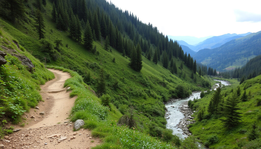
The route starts at the Wye Creek car park on SH6, then climbs through private farm land (access through a gate) to the hydro dam. From the dam, the track zigzags steeply up along the pipeline. DOC warns not to cross the dam and to climb away from the creek.
Location and scenery
The track offers views of the Wye Creek valley and the Remarkables. Rock climbing is available on both sides of the creek, with climbs up to 50 m, according to DOC.
What is the difficulty of Wye Creek track?
Graded as advanced by Destination Queenstown and some sources consider it moderate. The terrain is steep, rocky, and uneven. It requires good fitness and is not recommended for inexperienced hikers or those with mobility issues.
Grading and terrain
The track has steep sections, loose rocks, and a narrow path. Walking poles are recommended for the steep descent, as noted by Destination Queenstown.
Who should attempt this hike?
Experienced hikers comfortable with elevation gain and uneven ground. Beginners should consider easier Queenstown tracks like the Lake Hayes Loop.
Why is the Wye Creek track closed?
Closures may occur due to snow, ice, or avalanche risk in winter. Maintenance work or track damage can also cause temporary closures. Always check the official DOC website for up‑to‑date information before heading out.
Seasonal closures
Destination Queenstown states the track is only accessible in summer because it is a high-altitude track. Winter snow and ice make the route dangerous.
Weather-related closures
Heavy rain can cause rockfall or flooding. The track is exposed and can be unsafe in storms.
Current closure status
No active closure as of this writing. Verify with DOC before your trip.
How to get to the Lower Wye Creek Track trailhead?
Drive from Queenstown towards the Remarkables ski area on the gravel road. The trailhead is at the Wye Creek car park, about 20 minutes from Queenstown on SH6 toward Kingston, as per Destination Queenstown.
Driving directions from Queenstown
Head south on SH6 towards Kingston. After about 20 minutes, look for a gate on the left-hand side (heading south). The carpark is on private farm land.
Parking options
Parking is available at the trailhead but space may be limited. The road is unsealed; a vehicle with some ground clearance is recommended.
“The Wye Creek carpark is on private farm land accessed through a gate on the left-hand side of SH6 heading south.” – Destination Queenstown
“This steep track follows the pipeline from the dam and leads you to the foot of a rock bluff.” – Department of Conservation
annettewoodford.wordpress.com, freewalks.nz, twowillwander.com, doc.govt.nz, hikingscenery.com, hiiker.app, churnewzealand.com, odt.co.nz, trailforks.com
Frequently Asked Questions
Is the Lower Wye Creek Track dog‑friendly?
Not recommended due to steep terrain and private farm land. Dogs may disturb livestock.
Are there toilets on the track?
No toilets at the trailhead or along the track. Plan accordingly.
What should I wear for the hike?
Sturdy boots, layers, sun protection, and a rain jacket. Walking poles are advised.
Is there cell phone reception on the track?
Limited. Do not rely on GPS for navigation.
Can I combine this track with other trails in the Remarkables?
Experienced trampers can continue 6 to 8 hours to Lake Alta on an unmarked trail through challenging alpine terrain, as per the Kingston walks guide.
What wildlife might I see on the track?
Birds like kea and fantails, and possibly sheep on the private land.
Is the track suitable for trail running?
Only for advanced trail runners comfortable with steep, technical descents.
More related posts
 Cheap Flights to London – Best Tools and Tips for 2025
 King in the Ring – Muay Thai Rules and Verification
 Castlepoint Hotel & Guesthouse: Reviews & Amenities Guide
 Cake in a Cup: 3-Ingredient Microwave Mug Cake Recipes
 Wellington Sewage Leak 2026: Map, Updates & Health Risks
 Ninja Slushie NZ Price: Cost, Alternatives & Where to Buy
 APA 7th Referencing Generator – Best Free Tools 2025
 Yachts for Sale NZ: Find Used, Cheap & Luxury Yachts